Auction No 362, Category: Maps
5 Lots (displaying 1 - 5)
Workshop Manuals for Austin Morris 1800, BMC 1100 & Kestrel, and Morris Minor, all VG condition;
Workshop Manuals for Austin Morris 1800, BMC 1100 & Kestrel, and Morris Minor, all VG condition;
Lot 11
Lot: 11
- Auction Date: Wed 21st Sep 2016 12:00 BST (Ended)
- Est: £40 - £60
SOLD £20
MORE DETAILSWorkshop Manuals for Austin Morris 1800, BMC 1100 & Kestrel, and Morris Minor, all VG condition; together with folding Maps, chiefly OS especially c.1969/71 quarter-inch. (Qty)
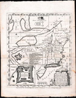
"A Map of New England and Country adjacent, extending Northward to Quebec, Westward to Niagara on Lake Ontario,
"A Map of New England and Country adjacent, extending Northward to Quebec, Westward to Niagara on Lake Ontario,
Lot 76
Lot: 76
- Auction Date: Wed 21st Sep 2016 12:00 BST (Ended)
- Est: £70 - £100
UNSOLD
MORE DETAILSA Map of New England and Country adjacent, extending Northward to Quebec, Westward to Niagara on Lake Ontario, shewing Gen. Shirley and Gen. Johnson’s Routs, W. Owen, London, 1755; inset plans of Fort Du Quesne & Fort Frederick. 20 x 17.5cm plus border, folds (as issued), one strengthened, VG; together with folding maps of British & French Settlements in North America in 2 parts (each 47 x 21cm, one torn), A New Map of Nova Scotia and Cape Britain with…parts of New England and Canada 1785 (46 x 55cm, very creased), and a Map of Paraguay by E. Bowen c.1759 (5)
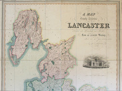
G. Hennet "A Map of the County Palatine of Lancaster divided into Hundreds and Parishes
G. Hennet "A Map of the County Palatine of Lancaster divided into Hundreds and Parishes
Lot 80
Lot: 80
- Auction Date: Wed 21st Sep 2016 12:00 BST (Ended)
- Est: £150 - £200
SOLD £100
MORE DETAILSG. Hennet A Map of the County Palatine of Lancaster divided into Hundreds and Parishes from an Accurate Survey made in the Years 1828 & 1829, Henry Teesdale, London, 1830; dissected folding map, linen-backed, hand-coloured; engraved vignette of the New Custom House, Liverpool, after R.I. Barrow; 160cm x 111cm, plus border. Fine. Housed in very worn leather-covered slipcase (most of title label missing). Our illustration only shows the top half of this map.
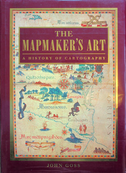
John Goss "The Mapmaker's Art: A History of Cartography" Studio Editions, 1993,
John Goss "The Mapmaker's Art: A History of Cartography" Studio Editions, 1993,
Lot 82
Lot: 82
- Auction Date: Wed 21st Sep 2016 12:00 BST (Ended)
- Est: £15 - £20
SOLD £10
MORE DETAILSJohn Goss The Mapmaker’s Art: A History of Cartography Studio Editions, 1993, large format h/b in d/jkt, superb illustrations Including fold-out maps.
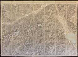
Alpine Maps 1910-1911, a selection published Edward Stanford (3) and Schweiz Landestopographie,
Alpine Maps 1910-1911, a selection published Edward Stanford (3) and Schweiz Landestopographie,
Lot 98
Lot: 98
- Auction Date: Wed 21st Sep 2016 12:00 BST (Ended)
- Est: £15 - £20
UNSOLD
MORE DETAILSAlpine Maps 1910-1911, a selection published Edward Stanford (3) and Schweiz Landestopographie, all dissected, linen-backed folding types,of areas around Theodulpass, Interlaken, Rhone Valley, and Sion. In card covers.(4)