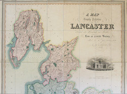
G. Hennet "A Map of the County Palatine of Lancaster divided into Hundreds and Parishes

- Lot No:
- 80
- Auction No:
- 362
- Auction Date:
- Wed 21st Sep 2016 12:00 (Ended)
SOLD £100
G. Hennet A Map of the County Palatine of Lancaster divided into Hundreds and Parishes from an Accurate Survey made in the Years 1828 & 1829, Henry Teesdale, London, 1830; dissected folding map, linen-backed, hand-coloured; engraved vignette of the New Custom House, Liverpool, after R.I. Barrow; 160cm x 111cm, plus border. Fine. Housed in very worn leather-covered slipcase (most of title label missing). Our illustration only shows the top half of this map.