Auction No 420, Category: Maps
5 Lots (displaying 1 - 5)
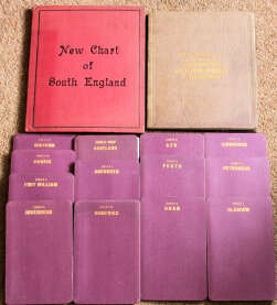
Selection of Maps by G.W. Bacon, comprising "Transport Map of South England and part of Wales", c.1923, districts of Scotland (set of 13),
Selection of Maps by G.W. Bacon, comprising "Transport Map of South England and part of Wales", c.1923, districts of Scotland (set of 13),
Lot 102
Lot: 102
- Auction Date: Wed 13th Sep 2023 12:00 BST (Ended)
- Est: £40 - £60
SOLD £44
MORE DETAILSSelection of Maps by G.W. Bacon, comprising Transport Map of South England and part of Wales, c.1923, districts of Scotland (set of 13), and Bacon's New Survey Map of Northampton, Huntingdon, Cambridge & Bedford. Cloth-backed, cloth-bound, all folding, Transport Map and New Survey very large. VG/VF (15)
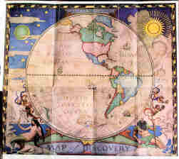
"The National Geographic Magazine", National Geographic Society, Washington, Jan.1928 - June 1929, with the two Maps of Discovery
"The National Geographic Magazine", National Geographic Society, Washington, Jan.1928 - June 1929, with the two Maps of Discovery
Lot 103
Lot: 103
- Auction Date: Wed 13th Sep 2023 12:00 BST (Ended)
- Est: £100 - £150
SOLD £82
MORE DETAILSThe National Geographic Magazine, National Geographic Society, Washington, Jan. 1928 – June 1929, with the two Maps of Discovery and one of the coloured frontispieces all by N.C. Wyeth. Cloth bound, gilt, fraying to top of spines o/w VG; the maps with vertical creases. (3 vols)
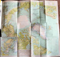
"The National Geographic Magazine", 1914-1919, July-Dec. 1923, and 1925, issue for November 1925 complete with folding map of Arctic Regions
"The National Geographic Magazine", 1914-1919, July-Dec. 1923, and 1925, issue for November 1925 complete with folding map of Arctic Regions
Lot 104
Lot: 104
- Auction Date: Wed 13th Sep 2023 12:00 BST (Ended)
- Est: £80 - £120
SOLD £125
MORE DETAILSThe National Geographic Magazine, 1914-1919, July-Dec.1923, and 1925, issue for November 1925 complete with folding map of Arctic Regions and five other folding maps in other vols., in good condition. Cloth bound, gilt, some wear, Vol.1 of 1914 lacking backstrip; all very clean internally. Also National Geographic Index 1888-1988 in d/jacket. (16 vols)
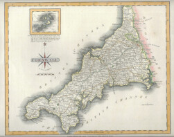
O.S. 1880s/1890s six-inch sheet maps, mostly locations in S.E. England, rolled, together with fine hand-coloured map of Cornwall by John Carey 1809,
O.S. 1880s/1890s six-inch sheet maps, mostly locations in S.E. England, rolled, together with fine hand-coloured map of Cornwall by John Carey 1809,
Lot 105
Lot: 105
- Auction Date: Wed 13th Sep 2023 12:00 BST (Ended)
- Est: £30 - £50
SOLD £18
MORE DETAILSO.S. 1880s/1890s six-inch sheet maps, mostly locations in S.E. England, rolled, together with fine hand-coloured map of Cornwall by John Carey 1809, and another. Fair to fine (22)
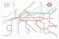
London Underground pocket maps 1961-87, mostly pre-1979 with ten 1960s. Includes issues No.1 and 3 for 1968. Good to VF (20)
London Underground pocket maps 1961-87, mostly pre-1979 with ten 1960s. Includes issues No.1 and 3 for 1968. Good to VF (20)
Lot 114
Lot: 114
- Auction Date: Wed 13th Sep 2023 12:00 BST (Ended)
- Est: £60 - £80
UNSOLD
MORE DETAILSLondon Underground pocket maps 1961-87, mostly pre-1979 with ten 1960s. Includes issues No.1 and 3 for 1968. Good to VF (20)