Auction No 363, Category: Maps
6 Lots (displaying 1 - 6)
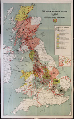
"Map of the London Midland and Scottish Railway showing areas of Associated Omnibus Undertakings",
"Map of the London Midland and Scottish Railway showing areas of Associated Omnibus Undertakings",
Lot 42
Lot: 42
- Auction Date: Wed 2nd Nov 2016 12:00 GMT (Ended)
- Est: £40 - £50
SOLD £92
MORE DETAILSMap of the London Midland and Scottish Railway showing areas of Associated Omnibus Undertakings, August, 1930, coloured, folding, 36 x 22”, complete Directory of Omnibus Services and depots on reverse.
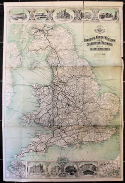
Portfolio of Maps late-19th and early-20th Century, many of Railway interest, much Cumbria & Furness area,
Portfolio of Maps late-19th and early-20th Century, many of Railway interest, much Cumbria & Furness area,
Lot 43
Lot: 43
- Auction Date: Wed 2nd Nov 2016 12:00 GMT (Ended)
- Est: £150 - £200
SOLD £100
MORE DETAILSPortfolio of Maps late-19th and early-20th Century, many of Railway interest, much Cumbria & Furness area, some Ireland and others; includes fine 1897 large hand-drawn Plan of Furness Railway showing distances between stations; attractive LNWR & Caledonian Map of England & Wales with vignettes (2, one partly soiled); LMS maps of Ireland; O.S. Maps with railway lines highlighted; LNWR Plan of Birkenhead, coloured (8, the same); etc. (abt. 52)
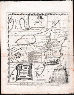
"A Map of New England and Country adjacent, extending Northward to Quebec, Westward to Niagara on Lake Ontario"
"A Map of New England and Country adjacent, extending Northward to Quebec, Westward to Niagara on Lake Ontario"
Lot 61
Lot: 61
- Auction Date: Wed 2nd Nov 2016 12:00 GMT (Ended)
- Est: £60 - £80
SOLD £30
MORE DETAILSA Map of New England and Country adjacent, extending Northward to Quebec, Westward to Niagara on Lake Ontario,shewing Gen. Shirley and Gen. Johnson’s Routs, W. Owen, London, 1755; inset plans of Fort Du Quesne & Fort Frederick. 20 x 17.5cm plus border, folds (as issued), one strengthened, VG; together with folding maps ofBritish & French Settlements in North America in 2 parts (each 47 x 21cm, one torn), A New Map of Nova Scotia and Cape Britain with…parts of New England and Canada 1785 (46 x 55cm, very creased), and a Map of Paraguay by E. Bowen c.1759 (5)
Selection of Maps including Manchester & Stockport 1930s (large, cloth-backed, coloured),
Selection of Maps including Manchester & Stockport 1930s (large, cloth-backed, coloured),
Lot 71
Lot: 71
- Auction Date: Wed 2nd Nov 2016 12:00 GMT (Ended)
- Est: £20 - £30
UNSOLD
MORE DETAILSSelection of Maps including Manchester & Stockport 1930s (large, cloth-backed, coloured), and an O.S. Map of Manchester & East Derbyshire 1906 (1” to 2miles). (5)
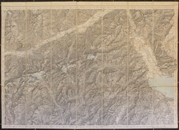
Alpine Maps 1910-1911, a selection published Edward Stanford (3) and Schweiz Landestopographie,
Alpine Maps 1910-1911, a selection published Edward Stanford (3) and Schweiz Landestopographie,
Lot 75
Lot: 75
- Auction Date: Wed 2nd Nov 2016 12:00 GMT (Ended)
- Est: £10 - £15
UNSOLD
MORE DETAILSAlpine Maps 1910-1911, a selection published Edward Stanford (3) and Schweiz Landestopographie, all dissected, linen-backed folding types,of areas around Theodulpass, Interlaken, Rhone Valley, and Sion. In card covers.(4)
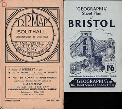
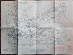
UK Folding Maps and Plans 1900s to 1970s with many town and city street plans, mainly 1930s & 1960s;
UK Folding Maps and Plans 1900s to 1970s with many town and city street plans, mainly 1930s & 1960s;
Lot 76
Lot: 76
- Auction Date: Wed 2nd Nov 2016 12:00 GMT (Ended)
- Est: £50 - £60
SOLD £26
MORE DETAILSUK Folding Maps and Plans 1900s to 1970s with many town and city street plans, mainly 1930s & 1960s; many are by ‘Geographia’. (74)